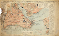
Plan de Byzance, Constantinople, Stamboul, Chrysopolis (Scutari), Chalcedoine (Kadı-keuy) - Suriçi (Fatih), Üsküdar, Kadıköy haritası
| DC Field | Value | Language |
|---|---|---|
| dc.provenance | Erhan Öner Koleksiyonu - Erhan Öner Collection | |
| dc.coverage.spatial | İstanbul | |
| dc.creator | [Alexandre Raymond] | |
| dc.date.accessioned | 2026-04-16T08:10:52Z | - |
| dc.date.available | 2026-04-16T08:10:52Z | - |
| dc.identifier | APLANIST32 | |
| dc.identifier.other | 134828 | |
| dc.identifier.uri | https://archives.saltresearch.org/handle/123456789/232525 | - |
| dc.format | Baskı - Print | |
| dc.format | El yazısı - Handwriting | |
| dc.format | Renkli - Color | |
| dc.language | Fransızca - French | |
| dc.rights | Open Access | |
| dc.source | A Journey Through Maps from the Constantinople to İstanbul Between the 16th and the 20th Centuries: The Cartographic Collection of Erhan Öner, İstanbul: Eren Yayıncılık, 2016, V4, ss. 138-139 | |
| dc.subject | Üsküdar | |
| dc.subject | Kadıköy | |
| dc.subject | Fatih | |
| dc.subject | Suriçi | |
| dc.subject | Haliç | |
| dc.subject | Golden Horn | |
| dc.title | Plan de Byzance, Constantinople, Stamboul, Chrysopolis (Scutari), Chalcedoine (Kadı-keuy) - Suriçi (Fatih), Üsküdar, Kadıköy haritası | |
| dc.type | Harita - Map | |
| dc.location | Salt Research | |
| dc.catalogedby | Masum Yıldız | |
| dc.date.cataloged | 2026-02-00 | |
| dc.format.numberofscans | 1 | |
| dc.format.numberofpages | 1 | |
| dcterms.accrualMethod | Satın alma - Purchase | |
| dc.rights.holder | Salt Araştırma - Salt Research | |
| Collections | Istanbul | |
Files
| File | Description | Size | Format | |
|---|---|---|---|---|
| APLANIST32.jpg | 10.12 MB | JPEG |