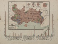
Balkan Savaşları sonucunda Bulgar ve Yunan işgali altına giren topraklardaki nüfus dağılımını gösteren harita - A map showing the distribution of population in the territories of Bulgarian and Greek occupation as a result of the Balkan Wars
| DC Field | Value | Language |
|---|---|---|
| dc.contributor | Le comité de la Thrace Occidentale - Batı Trakya Komitesi - Western Thrace Committee | - |
| dc.date.accessioned | 2018-09-24T10:04:51Z | - |
| dc.date.available | 2018-09-24T10:04:51Z | - |
| dc.identifier | ASTEO005 | - |
| dc.identifier.other | 126486 | - |
| dc.identifier.uri | https://archives.saltresearch.org/handle/123456789/121050 | - |
| dc.description | Haritanın ön yüzü - Front side of the map: "La proportion des propriétés foncierès. Carte de la Thrace Occidentale. Tableau Graphique de la Population de la Thrace Occidentale." | - |
| dc.format | 76,1-57,6 cm | - |
| dc.format | Baskı - Print | - |
| dc.format | Renkli - Colored | - |
| dc.language | Fransızca - French | - |
| dc.rights | Open Access | - |
| dc.subject | Osmanlı İmparatorluğu | - |
| dc.subject | Trakya | - |
| dc.subject | Thrace | - |
| dc.subject | Yunanistan | - |
| dc.subject | Greece | - |
| dc.subject | Bulgaristan | - |
| dc.subject | Bulgaria | - |
| dc.subject | Osmanlı Devleti | - |
| dc.subject | Ottoman Empire | - |
| dc.title | Balkan Savaşları sonucunda Bulgar ve Yunan işgali altına giren topraklardaki nüfus dağılımını gösteren harita - A map showing the distribution of population in the territories of Bulgarian and Greek occupation as a result of the Balkan Wars | - |
| dc.type | Harita - Map | - |
| dc.location | SALT Research | - |
| dc.catalogedby | Masum Yıldız | - |
| dc.date.cataloged | 2017-10-00 | - |
| dc.format.numberofscans | 1 | - |
| dc.format.numberofpages | 1 | - |
| dcterms.accrualMethod | Satın alma - Purchase | - |
| dc.rights.holder | SALT Araştırma - SALT Research | - |
| Collections | Western Thrace Committee | |
Files
| File | Description | Size | Format | |
|---|---|---|---|---|
| ASTEO005.jpg | 8.61 MB | JPEG |