[Map of Manisa]
| DC Field | Value | Language |
|---|---|---|
| dc.provenance | Amerikan Bord Heyeti, İstanbul - American Board, Istanbul | |
| dc.coverage.spatial | Manisa (Turkey) | |
| dc.date.accessioned | 2018-09-11T09:56:39Z | - |
| dc.date.available | 2018-09-11T09:56:39Z | - |
| dc.identifier | ABAHMNS001 | |
| dc.identifier.uri | https://archives.saltresearch.org/handle/123456789/45907 | - |
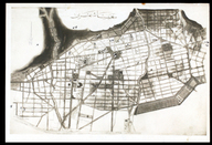
| dc.description | Manisa with a number of sites of importance labeled in a handwritten key on the reverse. There is Ottoman Turkish writing at the bottom of the map as "City of Manisa - Manisa şehri". "1. Sultan Camisi. 2. Muradiye Camisi. 3. Ulu Cami. 4. Mevlevi Hane (East of town). 5. Gok Tashlı Mosque (Göktaşlı Mosque). 6. Mevlevi Hane (in town). 7. Hospital for Insane. 8. Barraks. 9. Possible site - West of Hospital for Insane. 10. Ak Mescid Site, 11. Site of Schinasi Home. 12. Site above Schinasi Home - for hospital. 13. Sadik Bey Factory Site. 14. Cemetary Site. 15. Main Street Triangle Site. 16. Location of main water usevoir for West half of town as per Pont-a-mausson Water [Project]. 17. Ditto-location rexervoir for Higher section, per project. 18. Plot suggested as Hosp. possibility by Manissa officials. " | |
| dc.format | 16.5-23.8 cm | |
| dc.format | ||
| dc.format | Handwriting | |
| dc.format | Black&White | |
| dc.language | English | |
| dc.language | Ottoman Turkish | |
| dc.rights | Open Access | |
| dc.title | [Map of Manisa] | |
| dc.type | Harita fotoğrafı - Photograph of map | |
| dc.location | SALT Research | |
| dc.identifier.projectcode | ABA | |
| dc.catalogedby | ARIT & SALT Research staff | |
| dc.date.cataloged | 2016-00-00 | |
| dc.date.acquisition | 2010-12-00 | |
| dc.format.numberofscans | 2 | |
| dc.format.numberofpages | 1 | |
| dcterms.accrualMethod | On deposit at SALT Research from UCC and ARIT | |
| dc.rights.holder | United Church of Christ (UCC), American Research Institute in Turkey (ARIT), SALT Research | |
| Collections | Manisa | |
Files
| File | Description | Size | Format | |
|---|---|---|---|---|
| ABAHMNS001.jpg | 1.74 MB | JPEG | ||
| ABAHMNS001A1.jpg | 1.34 MB | JPEG |