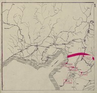
Map of secretly allocated troops of the ‘Armée Française du Levant’ [French Army in the East]. The map shows the region around the Gulf of Iskenderun.
| DC Field | Value | Language |
|---|---|---|
| dc.provenance | Auguste Sarrou | |
| dc.creator | ‘Bureau Topographique de l’Armée Française du Levant’ (Topographic Office of French Army in the East) | |
| dc.date.accessioned | 2018-09-09T18:23:13Z | - |
| dc.date.available | 2018-09-09T18:23:13Z | - |
| dc.date.issued | 1924-12 | |
| dc.identifier | AFMSRPLC001 | |
| dc.identifier.other | 83760 | |
| dc.identifier.uri | https://archives.saltresearch.org/handle/123456789/34817 | - |
| dc.description | Map of secretly allocated troops of the ‘Armée Française du Levant’ [French Army in the East]. The map shows the region around the Gulf of Iskenderun. The map has been drawn by the ‘Bureau Topographique de l’Armée Française du Levant’ (Topographic Office of French Army in the East) and it is the first of a series of 12 maps (according with the scheme placed on map n. 12 of Route map series) concerning the position of the battalions of the ‘Armée Française du Levant’ on the 7th of December 1924 within the territory of French Mandate of Syria and Lebanon. | |
| dc.format | 52,5-50 cm | |
| dc.format | Printed | |
| dc.language | Fransızca - French | |
| dc.rights | Open Access | |
| dc.title | Map of secretly allocated troops of the ‘Armée Française du Levant’ [French Army in the East]. The map shows the region around the Gulf of Iskenderun. | |
| dc.type | Harita - Map | |
| dc.note | On the backside there is a part of a canceled (‘Annulé’) map of Île-de-France e Champagne Ardenne (France) titled ‘Théâtre d’opérations du Nord-Est’ [Theatre of Operations at the northern-east front] likely dated back to World War I. | |
| dc.location | SALT Research | |
| dc.catalogedby | Francesco Malfatti | |
| dc.date.cataloged | January 2012 | |
| dc.date.acquisition | July 2011 | |
| dcterms.accrualMethod | Donation | |
| dc.rights.holder | Rachel Adrienne Sarrou | |
| Collections | Maps | |
Files
| File | Description | Size | Format | |
|---|---|---|---|---|
| AFMSRPLC001.jpg | 3.66 MB | JPEG |