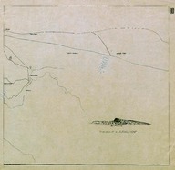
Route Map (Carte Routière) of the Syrian Desert region on the border among Iraq, Jordan and Syria.
| DC Field | Value | Language |
|---|---|---|
| dc.provenance | Auguste Sarrou | |
| dc.creator | ‘Bureau Topographique de l’Armée Française du Levant’ (Topographic Office of French Army in the East) | |
| dc.date.accessioned | 2018-09-09T18:23:10Z | - |
| dc.date.available | 2018-09-09T18:23:10Z | - |
| dc.date.issued | 1924-11 | |
| dc.identifier | AFMSRPLA010 | |
| dc.identifier.other | 83749 | |
| dc.identifier.uri | https://archives.saltresearch.org/handle/123456789/34816 | - |
| dc.description | Route Map (Carte Routière) of the Syrian Desert region on the border among Iraq, Jordan and Syria. On the map is drawn a sketch of Djebel Tenf, which is a hypsographic (hill) located in the area. The map has been drawn by the ‘Bureau Topographique de l’Armée Française du Levant’ (Topographic Office of French Army in the East) and it is the tenth of a series of 12 maps concerning the Iraqi and Syrian road and railway system according with the scheme placed on map n. 12. | |
| dc.format | 52,5-50 cm | |
| dc.format | Printed | |
| dc.language | Fransızca - French | |
| dc.rights | Open Access | |
| dc.title | Route Map (Carte Routière) of the Syrian Desert region on the border among Iraq, Jordan and Syria. | |
| dc.type | Harita - Map | |
| dc.note | On the backside there is a part of a canceled (‘Annulé’) map of southern Hesse and Franconia (Germany) likely dated back to World War I. | |
| dc.location | SALT Research | |
| dc.catalogedby | Francesco Malfatti | |
| dc.date.cataloged | January 2012 | |
| dc.date.acquisition | July 2011 | |
| dcterms.accrualMethod | Donation | |
| dc.rights.holder | Rachel Adrienne Sarrou | |
| Collections | Maps | |
Files
| File | Description | Size | Format | |
|---|---|---|---|---|
| AFMSRPLA010.jpg | 4.53 MB | JPEG |