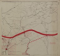
Map of secretly allocated troops of the ‘Armée Française du Levant’ [French Army in the East]. The map shows the region on the border between Turkey and Syria.
| Dublin Core Alanı | Değer | Dil |
|---|---|---|
| dc.provenance | Auguste Sarrou | |
| dc.creator | ‘Bureau Topographique de l’Armée Française du Levant’ (Topographic Office of French Army in the East) | |
| dc.date.accessioned | 2018-09-09T17:07:04Z | - |
| dc.date.available | 2018-09-09T17:07:04Z | - |
| dc.date.issued | 1924-12 | |
| dc.identifier | AFMSRPLC002 | |
| dc.identifier.other | 83761 | |
| dc.identifier.uri | https://archives.saltresearch.org/handle/123456789/33867 | - |
| dc.description | Map of secretly allocated troops of the ‘Armée Française du Levant’ [French Army in the East]. The map shows the region on the border between Turkey and Syria (in the extreme corners of the map there are placed the cities of Aleppo -Syria- and Siverek –Turkey-). The map has been drawn by the ‘Bureau Topographique de l’Armée Française du Levant’ (Topographic Office of French Army in the East) and it is the second of a series of 12 maps (according with the scheme placed on map n. 12 of Route map series) concerning the position of the battalions of the ‘Armée Française du Levant’ on the 7th of December 1924 within the territory of French Mandate of Syria and Lebanon. | |
| dc.format | 52,5-50 cm | |
| dc.format | Printed | |
| dc.language | Fransızca - French | |
| dc.rights | Open Access | |
| dc.title | Map of secretly allocated troops of the ‘Armée Française du Levant’ [French Army in the East]. The map shows the region on the border between Turkey and Syria. | |
| dc.type | Harita - Map | |
| dc.note | On the backside there is a part of a canceled (‘Annulé’) map of the northern-west coast of Algeria drawn in Paris in 1855 and titled ‘Carte Topographique des Environs d’Olréansville’. | |
| dc.location | SALT Research | |
| dc.catalogedby | Francesco Malfatti | |
| dc.date.cataloged | January 2012 | |
| dc.date.acquisition | July 2011 | |
| dcterms.accrualMethod | Donation | |
| dc.rights.holder | Rachel Adrienne Sarrou | |
| Koleksiyonlar | Maps | |
Dosyalar
| Dosya | Tanım | Boyut | Biçim | |
|---|---|---|---|---|
| AFMSRPLC002.jpg | 3.67 MB | JPEG |