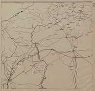
Route Map (Carte Routière) of the region on the border between Turkey and Syria
| DC Field | Value | Language |
|---|---|---|
| dc.provenance | Auguste Sarrou | |
| dc.creator | ‘Bureau Topographique de l’Armée Française du Levant’ (Topographic Office of French Army in the East) | |
| dc.date.accessioned | 2018-09-09T17:06:46Z | - |
| dc.date.available | 2018-09-09T17:06:46Z | - |
| dc.date.issued | 1924-11 | |
| dc.identifier | AFMSRPLA002 | |
| dc.identifier.other | 83741 | |
| dc.identifier.uri | https://archives.saltresearch.org/handle/123456789/33862 | - |
| dc.description | Route Map (Carte Routière) of the region on the border between Turkey and Syria (in the extreme corners of the map there are placed the cities of Aleppo -Syria- and Siverek –Turkey-). The map has been drawn by the ‘Bureau Topographique de l’Armée Française du Levant’ (Topographic Office of French Army in the East) and it is the second of a series of 12 maps concerning the Iraqi and Syrian road and railway system according with the scheme placed on map n. 12. | |
| dc.format | 52,5-50 cm | |
| dc.format | Printed | |
| dc.language | Fransızca - French | |
| dc.rights | Open Access | |
| dc.title | Route Map (Carte Routière) of the region on the border between Turkey and Syria | |
| dc.type | Harita - Map | |
| dc.note | On the backside there is a part of a canceled (‘Annulé’) map of southern Hesse and Franconia (Germany) likely dated back to World War I. | |
| dc.location | SALT Research | |
| dc.catalogedby | Francesco Malfatti | |
| dc.date.cataloged | January 2012 | |
| dc.date.acquisition | July 2011 | |
| dcterms.accrualMethod | Donation | |
| dc.rights.holder | Rachel Adrienne Sarrou | |
| Collections | Maps | |
Files
| File | Description | Size | Format | |
|---|---|---|---|---|
| AFMSRPLA002.jpg | 3.63 MB | JPEG |