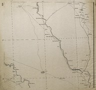
Route Map (Carte Routière) of the region is north of Baghdad (Iraq).
| DC Field | Value | Language |
|---|---|---|
| dc.provenance | Auguste Sarrou | |
| dc.creator | ‘Bureau Topographique de l’Armée Française du Levant’ (Topographic Office of French Army in the East) | |
| dc.date.accessioned | 2018-09-09T15:41:45Z | - |
| dc.date.available | 2018-09-09T15:41:45Z | - |
| dc.date.issued | 1924-11 | |
| dc.identifier | AFMSRPLA008 | |
| dc.identifier.other | 83747 | |
| dc.identifier.uri | https://archives.saltresearch.org/handle/123456789/32927 | - |
| dc.description | Route Map (Carte Routière) of the region is north of Baghdad (Iraq). The course of Tigris River is clearly indicated on the map. . The map has been drawn by the ‘Bureau Topographique de l’Armée Française du Levant’ (Topographic Office of French Army in the East) and it is the eighth of a series of 12 maps concerning the Iraqi and Syrian road and railway system according with the scheme placed on map n. 12. | |
| dc.format | 52,5-48 cm | |
| dc.format | Printed | |
| dc.language | Fransızca - French | |
| dc.rights | Open Access | |
| dc.title | Route Map (Carte Routière) of the region is north of Baghdad (Iraq). | |
| dc.type | Harita - Map | |
| dc.location | SALT Research | |
| dc.catalogedby | Francesco Malfatti | |
| dc.date.cataloged | January 2012 | |
| dc.date.acquisition | July 2011 | |
| dcterms.accrualMethod | Donation | |
| dc.rights.holder | Rachel Adrienne Sarrou | |
| Collections | Maps | |
Files
| File | Description | Size | Format | |
|---|---|---|---|---|
| AFMSRPLA008.jpg | 3.96 MB | JPEG |