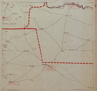
French Mandate of Syria and Lebanon Province Map. The map shows the region is east of Homs (Syria).
| DC Field | Value | Language |
|---|---|---|
| dc.provenance | Auguste Sarrou | |
| dc.creator | ‘Bureau Topographique de l’Armée Française du Levant’ (Topographic Office of French Army in the East) | |
| dc.date.accessioned | 2018-09-09T14:43:47Z | - |
| dc.date.available | 2018-09-09T14:43:47Z | - |
| dc.identifier | AFMSRPLB006 | |
| dc.identifier.other | 83756 | |
| dc.identifier.uri | https://archives.saltresearch.org/handle/123456789/32018 | - |
| dc.description | French Mandate of Syria and Lebanon Province Map. The map shows the region is east of Homs (Syria). The map has been drawn by the ‘Bureau Topographique de l’Armée Française du Levant’ (Topographic Office of French Army in the East) and it is the sixth of a series of 12 maps concerning the administrative division of French Mandate of Syria and Lebanon according with the scheme placed on map n. 12 of Route map series. Continuous lines indicate national border, broken lines indicate Sanjaks border and dotted lines indicate Cezas border. | |
| dc.format | 52,5-49 cm | |
| dc.format | Printed | |
| dc.language | Fransızca - French | |
| dc.rights | Open Access | |
| dc.title | French Mandate of Syria and Lebanon Province Map. The map shows the region is east of Homs (Syria). | |
| dc.type | Harita - Map | |
| dc.note | On the backside there is a part of a canceled (‘Annulé’) map of southern Hesse and Franconia (Germany) likely dated back to World War I. | |
| dc.location | SALT Research | |
| dc.catalogedby | Francesco Malfatti | |
| dc.date.cataloged | January 2012 | |
| dc.date.acquisition | July 2011 | |
| dcterms.accrualMethod | Donation | |
| dc.rights.holder | Rachel Adrienne Sarrou | |
| Collections | Maps | |
Files
| File | Description | Size | Format | |
|---|---|---|---|---|
| AFMSRPLB006.jpg | 3.13 MB | JPEG |