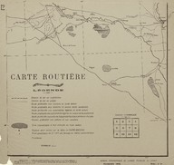
Route Map (Carte Routière) of the region is south-west of Baghdad (Iraq).
| DC Field | Value | Language |
|---|---|---|
| dc.provenance | Auguste Sarrou | |
| dc.creator | ‘Bureau Topographique de l’Armée Française du Levant’ (Topographic Office of French Army in the East) | |
| dc.date.accessioned | 2018-09-09T13:03:32Z | - |
| dc.date.available | 2018-09-09T13:03:32Z | - |
| dc.date.issued | 1924-11 | |
| dc.identifier | AFMSRPLA012 | |
| dc.identifier.other | 83751 | |
| dc.identifier.uri | https://archives.saltresearch.org/handle/123456789/31016 | - |
| dc.description | Route Map (Carte Routière) of the region is south-west of Baghdad (Iraq). The map has been drawn by the ‘Bureau Topographique de l’Armée Française du Levant’ (Topographic Office of French Army in the East) in November 1924 and it is the eleventh of a series of 12 maps concerning the Iraqi and Syrian road and railway system according with the scheme placed on the same map. On the left lower corner is placed the legend. | |
| dc.format | 52,5-50 cm | |
| dc.format | Printed | |
| dc.language | Fransızca - French | |
| dc.rights | Open Access | |
| dc.title | Route Map (Carte Routière) of the region is south-west of Baghdad (Iraq). | |
| dc.type | Harita - Map | |
| dc.location | SALT Research | |
| dc.catalogedby | Francesco Malfatti | |
| dc.date.cataloged | January 2012 | |
| dc.date.acquisition | July 2011 | |
| dcterms.accrualMethod | Donation | |
| dc.rights.holder | Rachel Adrienne Sarrou | |
| Collections | Maps | |
Files
| File | Description | Size | Format | |
|---|---|---|---|---|
| AFMSRPLA012.jpg | 3.5 MB | JPEG |