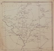
Route Map (Carte Routière) of the Syrian and Lebanese coast region between the cities of Tripoli (Lebanon) and Latakia (Syria).
| Dublin Core Alanı | Değer | Dil |
|---|---|---|
| dc.provenance | Auguste Sarrou | |
| dc.creator | ‘Bureau Topographique de l’Armée Française du Levant’ (Topographic Office of French Army in the East) | |
| dc.date.accessioned | 2018-09-09T11:37:34Z | - |
| dc.date.available | 2018-09-09T11:37:34Z | - |
| dc.date.issued | 1924-11 | |
| dc.identifier | AFMSRPLA004 | |
| dc.identifier.other | 83743 | |
| dc.identifier.uri | https://archives.saltresearch.org/handle/123456789/29999 | - |
| dc.description | Route Map (Carte Routière) of the northern region of Iraq. The cities of Duhok, Rawanduz and Mosul are indicated on the map. The map has been drawn by the ‘Bureau Topographique de l’Armée Française du Levant’ (Topographic Office of French Army in the East) and it is the fourth of a series of 12 maps concerning the Iraqi and Syrian road and railway system according with the scheme placed on map n. 12. | |
| dc.format | 52,5-48 cm | |
| dc.format | Printed | |
| dc.language | Fransızca - French | |
| dc.rights | Open Access | |
| dc.title | Route Map (Carte Routière) of the Syrian and Lebanese coast region between the cities of Tripoli (Lebanon) and Latakia (Syria). | |
| dc.type | Harita - Map | |
| dc.location | SALT Research | |
| dc.catalogedby | Francesco Malfatti | |
| dc.date.cataloged | January 2012 | |
| dc.date.acquisition | July 2011 | |
| dcterms.accrualMethod | Donation | |
| dc.rights.holder | Rachel Adrienne Sarrou | |
| Koleksiyonlar | Maps | |
Dosyalar
| Dosya | Tanım | Boyut | Biçim | |
|---|---|---|---|---|
| AFMSRPLA004.jpg | 4.33 MB | JPEG |