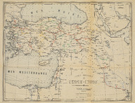
Carte Generale de l'Empire Ottoman, Echele 1/400000 - Osmanlı İmparatorluğu Genel Haritası, Ölçek: 1/400000 - General Map of the Ottoman Empire, Scale 1/400000
| DC Field | Value | Language |
|---|---|---|
| dc.provenance | Erhan Öner Koleksiyonu - Erhan Öner Collection | |
| dc.contributor | Onnik | |
| dc.date.accessioned | 2026-04-16T08:10:55Z | - |
| dc.date.available | 2026-04-16T08:10:55Z | - |
| dc.identifier | APLNZM001 | |
| dc.identifier.other | 134828 | |
| dc.identifier.uri | https://archives.saltresearch.org/handle/123456789/232539 | - |
| dc.description | İşleyen, inşaat hâlindeki, imtiyazı alınmış demiryolları ve petrol yataklarını gösteren harita. - A map depicting railways in operation, under construction, and under concession, along with oil fields. | |
| dc.format | Baskı - Print | |
| dc.format | Renkli - Color | |
| dc.language | Fransızca - French | |
| dc.language | Osmanlı Türkçesi - Ottoman Turkish | |
| dc.publisher | Nafia Nezareti Matbaası | |
| dc.rights | Open Access | |
| dc.source | A Journey Through Maps from the Ottoman World to the Republic of Turkey Between the 15th and the 20th Centuries: The Cartographic Collection of Erhan Öner, İstanbul: Eren Yayıncılık, 2016, V2, s. 352 | |
| dc.subject | Tren yolu | |
| dc.subject | Demiryolu | |
| dc.subject | Demir yolu | |
| dc.subject | Railway | |
| dc.subject | Petrol | |
| dc.subject | Oil | |
| dc.subject | Onnik | |
| dc.title | Carte Generale de l'Empire Ottoman, Echele 1/400000 - Osmanlı İmparatorluğu Genel Haritası, Ölçek: 1/400000 - General Map of the Ottoman Empire, Scale 1/400000 | |
| dc.type | Harita - Map | |
| dc.location | Salt Research | |
| dc.catalogedby | Masum Yıldız | |
| dc.date.cataloged | 2026-02-00 | |
| dc.format.numberofscans | 1 | |
| dc.format.numberofpages | 1 | |
| dcterms.accrualMethod | Satın alma - Purchase | |
| dc.rights.holder | Salt Araştırma - Salt Research | |
| Collections | Nafia Nezareti Matbaası | |
Files
| File | Description | Size | Format | |
|---|---|---|---|---|
| APLNZM001.jpg | 10.77 MB | JPEG |