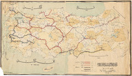
Türkiye Cumhuriyeti Demiryolları Haritası, Mikyas 1/1500000 - Carte Géographique de Chemins de Fer de L'etat de la République Turquie, 1/1500000
| Dublin Core Alanı | Değer | Dil |
|---|---|---|
| dc.provenance | Erhan Öner Koleksiyonu - Erhan Öner Collection | |
| dc.coverage.spatial | Türkiye | |
| dc.creator | Nafia Vekaleti Demiryolları Heyet-i Fenniyesi | |
| dc.date.accessioned | 2026-04-16T08:10:55Z | - |
| dc.date.available | 2026-04-16T08:10:55Z | - |
| dc.date.issued | 1927 | |
| dc.identifier | APLNVD001 | |
| dc.identifier.other | 134828 | |
| dc.identifier.uri | https://archives.saltresearch.org/handle/123456789/232538 | - |
| dc.format | Baskı - Print | |
| dc.format | Renkli - Color | |
| dc.language | Fransızca - French | |
| dc.language | Osmanlı Türkçesi - Ottoman Turkish | |
| dc.rights | Open Access | |
| dc.source | A Journey Through Maps from the Ottoman World to the Republic of Turkey Between the 15th and the 20th Centuries: The Cartographic Collection of Erhan Öner, İstanbul: Eren Yayıncılık, 2016, V2, s. 358 | |
| dc.subject | Tren yolu | |
| dc.subject | Demiryolu | |
| dc.subject | Demir yolu | |
| dc.subject | Railway | |
| dc.title | Türkiye Cumhuriyeti Demiryolları Haritası, Mikyas 1/1500000 - Carte Géographique de Chemins de Fer de L'etat de la République Turquie, 1/1500000 | |
| dc.type | Harita - Map | |
| dc.location | Salt Research | |
| dc.catalogedby | Masum Yıldız | |
| dc.date.cataloged | 2026-02-00 | |
| dc.format.numberofscans | 1 | |
| dc.format.numberofpages | 1 | |
| dcterms.accrualMethod | Satın alma - Purchase | |
| dc.rights.holder | Salt Araştırma - Salt Research | |
| Koleksiyonlar | Nafia Vekaleti Demiryolları Heyet-i Fenniyesi | |
Dosyalar
| Dosya | Tanım | Boyut | Biçim | |
|---|---|---|---|---|
| APLNVD001.jpg | 7.07 MB | JPEG |