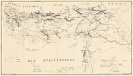
Osmanlı İmparatorluğu ulaşım haritası, Ölçek 1/3000000 - Transportation map of the Ottoman Empire, Scale 1/3000000
| DC Field | Value | Language |
|---|---|---|
| dc.provenance | Erhan Öner Koleksiyonu - Erhan Öner Collection | |
| dc.coverage.spatial | Türkiye | |
| dc.creator | La Construction Moderne | |
| dc.date.accessioned | 2026-04-16T08:10:54Z | - |
| dc.date.available | 2026-04-16T08:10:54Z | - |
| dc.identifier | APLLCM001 | |
| dc.identifier.other | 134828 | |
| dc.identifier.uri | https://archives.saltresearch.org/handle/123456789/232533 | - |
| dc.description | 1326-1328 tarihlerinde programlanan demir yolu rotalarını içerir. - The map includes railway routes planned between 1326 and 1328. | |
| dc.format | Baskı - Print | |
| dc.format | Siyah Beyaz - Black & White | |
| dc.language | Fransızca - French | |
| dc.rights | Open Access | |
| dc.source | A Journey Through Maps from the Ottoman World to the Republic of Turkey Between the 15th and the 20th Centuries: The Cartographic Collection of Erhan Öner, İstanbul: Eren Yayıncılık, 2016, V2, s. 349 | |
| dc.subject | Tren yolu | |
| dc.subject | Demiryolu | |
| dc.subject | Demir yolu | |
| dc.subject | Railway | |
| dc.subject | Karayolu | |
| dc.subject | Highway | |
| dc.subject | Ulaşım | |
| dc.subject | Transportation | |
| dc.title | Osmanlı İmparatorluğu ulaşım haritası, Ölçek 1/3000000 - Transportation map of the Ottoman Empire, Scale 1/3000000 | |
| dc.type | Harita - Map | |
| dc.location | Salt Research | |
| dc.catalogedby | Masum Yıldız | |
| dc.date.cataloged | 2026-02-00 | |
| dc.format.numberofscans | 1 | |
| dc.format.numberofpages | 1 | |
| dcterms.accrualMethod | Satın alma - Purchase | |
| dc.rights.holder | Salt Araştırma - Salt Research | |
| Collections | La Construction Moderne | |
Files
| File | Description | Size | Format | |
|---|---|---|---|---|
| APLLCM001.jpg | 5.87 MB | JPEG |