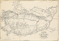
İzmir’in doğusundaki bölgenin haritası; Kasaba - Aydın demiryolu Haritası, Ölçek 1/500000 - Map of the country east of Smyrna, Showing the Railways to Kassaba & Aidin, Scale 1/500000
| DC Field | Value | Language |
|---|---|---|
| dc.provenance | Erhan Öner Koleksiyonu - Erhan Öner Collection | |
| dc.coverage.spatial | Aydın | |
| dc.coverage.spatial | İzmir | |
| dc.creator | C.E. Austin & E.G. Ravenstein | |
| dc.date.accessioned | 2026-04-16T08:10:52Z | - |
| dc.date.available | 2026-04-16T08:10:52Z | - |
| dc.date.issued | 1873-04 | |
| dc.identifier | APLARN001 | |
| dc.identifier.other | 134828 | |
| dc.identifier.uri | https://archives.saltresearch.org/handle/123456789/232528 | - |
| dc.format | Baskı - Print | |
| dc.format | Siyah Beyaz - Black & White | |
| dc.language | İngilizce - English | |
| dc.rights | Open Access | |
| dc.source | A Journey Through Maps from the Ottoman World to the Republic of Turkey Between the 15th and the 20th Centuries: The Cartographic Collection of Erhan Öner, İstanbul: Eren Yayıncılık, 2016, V2, s. 344 https://babel.hathitrust.org/cgi/pt?id=nyp.33433000027007&seq=28&view=1up | |
| dc.subject | Tren yolu | |
| dc.subject | Demiryolu | |
| dc.subject | Demir yolu | |
| dc.subject | Railway | |
| dc.subject | Aydın | |
| dc.subject | Kasaba | |
| dc.subject | İzmir | |
| dc.title | İzmir’in doğusundaki bölgenin haritası; Kasaba - Aydın demiryolu Haritası, Ölçek 1/500000 - Map of the country east of Smyrna, Showing the Railways to Kassaba & Aidin, Scale 1/500000 | |
| dc.type | Harita - Map | |
| dc.note | Ocean Highways: The Geographical Review, (London: N. Trübner and Co. April 1873, ss. 8-10) dergisinden "Railways in Asia Minor" makalesi ekidir. | |
| dc.location | Salt Research | |
| dc.catalogedby | Masum Yıldız | |
| dc.date.cataloged | 2026-02-00 | |
| dc.format.numberofscans | 1 | |
| dc.format.numberofpages | 1 | |
| dcterms.accrualMethod | Satın alma - Purchase | |
| dc.rights.holder | Salt Araştırma - Salt Research | |
| Collections | C.E. Austin & E.G. Ravenstein | |
Files
| File | Description | Size | Format | |
|---|---|---|---|---|
| APLARN001.jpg | 7.6 MB | JPEG |