| File | Description | Size | Format | |
|---|---|---|---|---|
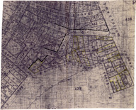
| AHISTBEYO127001.jpg | Ada haritası - Map of the plot | 37.09 MB | JPEG | |
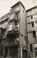
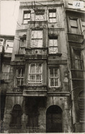
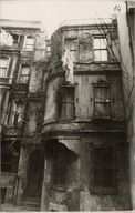
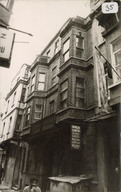
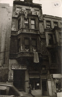
| AHISTBEYO127002.jpg | 3 numaralı yapı - Building no. 3 | 4.09 MB | JPEG | |
| AHISTBEYO127002A.jpg | 2.86 MB | JPEG | ||
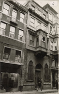
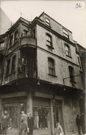
| AHISTBEYO127003.jpg | 4 numaralı yapı - Building no. 4 | 4.3 MB | JPEG | |
| AHISTBEYO127003A.jpg | 2.94 MB | JPEG | ||
| AHISTBEYO127004.jpg | 12 numaralı yapı - Building no. 12 | 4.35 MB | JPEG | |
| AHISTBEYO127004A.jpg | 3.04 MB | JPEG | ||
| AHISTBEYO127005.jpg | 14 numaralı yapı - Building no. 14 | 4.02 MB | JPEG | |
| AHISTBEYO127005A.jpg | 3.02 MB | JPEG | ||
| AHISTBEYO127006.jpg | 15 numaralı yapı - Building no. 15 | 4.12 MB | JPEG | |
| AHISTBEYO127006A.jpg | 3.24 MB | JPEG | ||
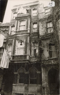
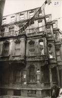
| AHISTBEYO127007.jpg | 21 numaralı yapı - Building no. 21 | 3.71 MB | JPEG | |
| AHISTBEYO127007A.jpg | 3.23 MB | JPEG | ||
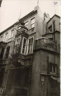
| AHISTBEYO127008.jpg | 30 numaralı yapı - Building no. 30 | 3.6 MB | JPEG | |
| AHISTBEYO127008A.jpg | 3.2 MB | JPEG | ||
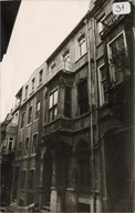
| AHISTBEYO127009.jpg | 31 numaralı yapı - Building no. 31 | 3.83 MB | JPEG | |
| AHISTBEYO127009A.jpg | 3.28 MB | JPEG | ||
| AHISTBEYO127010.jpg | 35 numaralı yapı - Building no. 35 | 3.72 MB | JPEG | |
| AHISTBEYO127010A.jpg | 3.17 MB | JPEG | ||
| AHISTBEYO127011.jpg | 36 numaralı yapı - Building no. 36 | 3.63 MB | JPEG | |
| AHISTBEYO127011A.jpg | 3.25 MB | JPEG | ||
| AHISTBEYO127012.jpg | 38 numaralı yapı - Building no. 38 | 3.79 MB | JPEG | |
| AHISTBEYO127012A.jpg | 3.13 MB | JPEG | ||
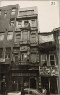
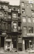
| AHISTBEYO127013.jpg | 40 numaralı yapı - Building no. 40 | 3.66 MB | JPEG | |
| AHISTBEYO127013A.jpg | 3.19 MB | JPEG | ||
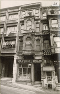
| AHISTBEYO127014.jpg | 41 numaralı yapı - Building no. 41 | 3.98 MB | JPEG | |
| AHISTBEYO127014A.jpg | 3.27 MB | JPEG | ||
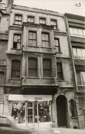
| AHISTBEYO127015.jpg | 43 numaralı yapı - Building no. 43 | 3.93 MB | JPEG | |
| AHISTBEYO127015A.jpg | 3.11 MB | JPEG | ||
| AHISTBEYO127016.jpg | 44 numaralı yapı - Building no. 44 | 4.09 MB | JPEG | |
| AHISTBEYO127016A.jpg | 3.21 MB | JPEG |
RIGHTS STATEMENT
Salt is a partner of Flickr Commons. All visual materials within Flickr Commons and digitized by Salt Research which are accessible via saltresearch.org are shared under the Creative Commons license:
This material is provided solely for the purpose of individual research. It can be used under Creative Commons Attribution-NonCommercial-NoDerivatives 4.0 International (CC BY-NC-ND 4.0) license. The terms specified hereunder:
• The creator or the licensor of the work should be stated in all copies,
• Copies of documents, or documents created from copies can not be used commercially,
• Documents can not be remixed, transformed or built upon.
For each use, credits should be given as stated in the record.
(e.g. Salt Research, Harika-Kemali Söylemezoğlu Archive)
For any rights requests outside of personal research purposes, please contact Salt Research via salt.research@saltonline.org