| File | Description | Size | Format | |
|---|---|---|---|---|
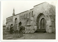
| TEGH105001.jpg | Sultan II. Kılıçarslan Köşkü harabeleri, Konya. İnşa tarihi: 1156-1192. Koordinatlar: 37.874186, 32.492642 - Ruins of Sultan Kılıçarslan II Palace. Date of construction: 1156-1192. Coordinates: 37.874186, 32.492642 | 626.32 KB | JPEG | |
| TEGH105001A.jpg | 65.29 KB | JPEG | ||
| TEGH105002.jpg | Şems-i Tebrizi Türbesi ve Camii, Konya. Koordinatlar: 37.873723, 32.497486 - Shams Tabrizi Tomb and Mosque, Konya. Coordinates: 37.873723, 32.497486 | 669.66 KB | JPEG | |
| TEGH105002A.jpg | 65.24 KB | JPEG | ||
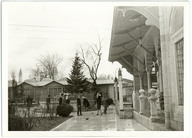
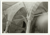
| TEGH105003.jpg | Mevlana Müzesi, Konya. Koordinatlar: 37.870686, 32.504785 - Mevlana Museum. Corrdinates: 37.870686, 32.504785 | 573.1 KB | JPEG | |
| TEGH105003A.jpg | 64.39 KB | JPEG | ||
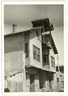
| TEGH105004.jpg | Bir konut, Ereğli, Konya - A house, Ereğli, Konya | 605.13 KB | JPEG | |
| TEGH105004A.jpg | 67.61 KB | JPEG | ||
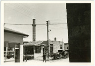
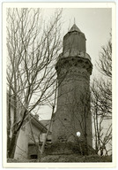
| TEGH105005.jpg | Ereğli Ulu Camii minaresi, Ereğli, Konya. Koordinatlar: 37.514054, 34.049818 - Grand Mosque of Ereğli minaret, Ereğli, Konya. Coordinates: 37.514054, 34.049818 | 589.53 KB | JPEG | |
| TEGH105005A.jpg | 60.25 KB | JPEG | ||
| TEGH105006.jpg | Ereğli Ulu Camii minare kürsüsü, Ereğli, Konya. Koordinatlar: 37.514054, 34.049818 - Grand Mosque of Ereğli minaret pulpit, Ereğli, Konya. Coordinates: 37.514054, 34.049818 | 580.77 KB | JPEG | |
| TEGH105006A.jpg | 68.14 KB | JPEG | ||
| TEGH105007.jpg | Mevlana Müzesi, Konya. Koordinatlar: 37.870686, 32.504785 - Mevlana Museum. Coordinates: 37.870686, 32.504785 | 554.79 KB | JPEG | |
| TEGH105007A.jpg | 64.8 KB | JPEG | ||
| TEGH105008.jpg | Aziziye Camii, Konya. İnşa tarihi: 1867. Koordinatlar: 37.870054, 32.500646 - Aziziye Mosque, Konya. Date of construction: 1867. Coordinates: 37.870054, 32.500646 | 563.5 KB | JPEG | |
| TEGH105008A.jpg | 65.2 KB | JPEG | ||
| TEGH105009.jpg | Bir konut, Ereğli, Konya - A house, Ereğli, Konya | 577.62 KB | JPEG | |
| TEGH105009A.jpg | 70.82 KB | JPEG | ||
| TEGH105010.jpg | Mevlana Müzesi, Konya. Koordinatlar: 37.870686, 32.504785 - Mevlana Museum. Coordinates: 37.870686, 32.504785 | 512.13 KB | JPEG | |
| TEGH105010A.jpg | 66.01 KB | JPEG | ||
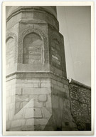
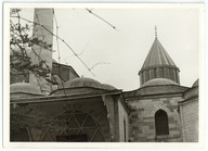
| TEGH105011.jpg | Hatuniye Camii Minaresi (Güdük Minare), Konya. Koordinatlar: 37.874276, 32.496198 - Hatuniye Mosque Minaret (Güdük Minaret), Konya. Coordinates: 37.874276, 32.496198 | 782.51 KB | JPEG | |
| TEGH105011A.jpg | 61.76 KB | JPEG | ||
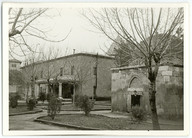
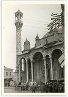
| TEGH105012.jpg | Alaeddin Camii, Konya. İnşa tarihi: 1155. Koordinatlar: 37.873632, 32.493008 - Alaeddin Mosque, Konya. Date of construction: 1155. Coordinates: 37.873632, 32.493008 | 606.43 KB | JPEG | |
| TEGH105012A.jpg | 67.77 KB | JPEG | ||
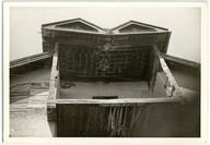
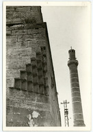
| TEGH105013.jpg | (Önde) Rüstem Paşa Kervansarayı köşe mukarnas detayı ve (arkada) Ereğli Ulu Camii minaresi, Ereğli, Konya. Koordinatlar: 37.514540, 34.049676 - (In the foreground) Corner muqarnas detal of Rüstem Pasha Caravanserai and (in the background) Grand Mosque of Ereğli minaret, Ereğli, Konya. Coordinates: 37.514540, 34.049676 | 602.67 KB | JPEG | |
| TEGH105014.jpg | Bir konut, Ereğli, Konya - A house, Ereğli, Konya | 621.29 KB | JPEG | |
| TEGH105014A.jpg | 70.01 KB | JPEG |


RIGHTS STATEMENT
Salt is a partner of Flickr Commons. All visual materials within Flickr Commons and digitized by Salt Research which are accessible via saltresearch.org are shared under the Creative Commons license:
This material is provided solely for the purpose of individual research. It can be used under Creative Commons Attribution-NonCommercial-NoDerivatives 4.0 International (CC BY-NC-ND 4.0) license. The terms specified hereunder:
• The creator or the licensor of the work should be stated in all copies,
• Copies of documents, or documents created from copies can not be used commercially,
• Documents can not be remixed, transformed or built upon.
For each use, credits should be given as stated in the record.
(e.g. Salt Research, Harika-Kemali Söylemezoğlu Archive)
For any rights requests outside of personal research purposes, please contact Salt Research via salt.research@saltonline.org