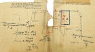
Topçular Caddesi'nde bulunan emlakların eski ve yeni vaziyetlerini gösteren harita - The map showing old and new conditions of properties in Topçular Street (Mikyas - Scale 1:100)
| DC Field | Value | Language |
|---|---|---|
| dc.coverage.spatial | Karaköy, İstanbul | |
| dc.date.accessioned | 2018-12-18T10:38:17Z | - |
| dc.date.available | 2018-12-18T10:38:17Z | - |
| dc.date.issued | 1925-01-14 | |
| dc.identifier | AHANBPL002 | |
| dc.identifier.other | 126395 | |
| dc.identifier.uri | https://archives.saltresearch.org/handle/123456789/192181 | - |
| dc.description | Kasapyan Efendi ve Madam Roza ile diğerlerine ait olan mülkleri göstermektedir. 19 Nisan 1339'da mevcut istimlak haritasına ve mahallen yapılan […] göre tanzim edilmiştir. 14 Kanunisani 1341'de kopya edilmiştir. - Shows the property belonging to Kasapyan Efendi, Madam Roza and others. It is put in order according to the expropriation map and local [...] in 19 April 1339. | |
| dc.format | 44,4-24,4 cm; 51,9-43,5 cm | |
| dc.format | El yazısı - Handwriting | |
| dc.language | Osmanlı Türkçesi - Ottoman Turkish | |
| dc.rights | Open Access | |
| dc.subject | Galata | |
| dc.subject | Vaziyet Planı | |
| dc.subject | Site plan | |
| dc.title | Topçular Caddesi'nde bulunan emlakların eski ve yeni vaziyetlerini gösteren harita - The map showing old and new conditions of properties in Topçular Street (Mikyas - Scale 1:100) | |
| dc.type | Harita - Map | |
| dc.location | SALT Research | |
| dc.catalogedby | Masum Yıldız | |
| dc.date.cataloged | 2017-03-00 | |
| dc.format.numberofscans | 2 | |
| dc.format.numberofpages | 2 | |
| dcterms.accrualMethod | Satın alma - Purchase | |
| dc.rights.holder | SALT Araştırma - SALT Research | |
| Collections | Maps | |
Files
| File | Description | Size | Format | |
|---|---|---|---|---|
| AHANBPL002001.jpg | 1.6 MB | JPEG | ||
| AHANBPL002002.jpg | 2.2 MB | JPEG |