SEARCH
FILTER
REFINE
| Preview | Title | Creator | Issue Date |
|---|---|---|---|
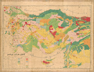 | Anadolu ilm-i arz haritası (Mikyas 1:1.500.00) | Damad Kenan; Ahmed Malik | 1920 |
 | Plan Mersine - Mersin Haritası | - | - |
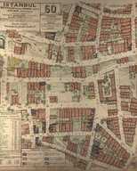 | Gayrımenkul haritası. İstanbul. Beyoğlu Kazası - Taksim Nahiyesi, 'Bülbül' Mahallesi. No: 60. | Jacques Pervititch | 1944 |
 | Gayrımenkul haritası. İstanbul. Beyoğlu Kazası - Taksim Nahiyesi, Şehit Muhtar Bey Mahallesi. No: 27. | Jacques Pervititch | 1944 |
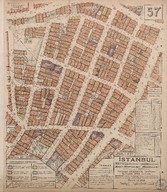 | Beyoğlu Kazası, Taksim Nahiyesi, Şehit Muhtar Bey Mahallesi. Gayrimenkul haritası, No: 57 - Beyoğlu, Taksim, Şehit Muhtar Bey Quarter. Property Map, Nr. 57 [1:375] | Jacques Pervititch | 1944-11 |
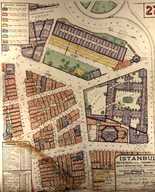
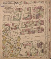 | Aksaray, Kemalpaşa [1:500], no. 53. Sigorta planı - Plan d'assurances - Insurance plan | Jacques Pervititch | 1936 |
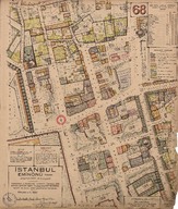 | Eminönü, Mercan Ağa, [1:500]. Sigorta planı, no. 68 - Insurance plan, nr. 68 | Jacques Pervititch | 1941-07 |
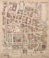 | Plan d'assurances. Fatih. No: 18. | Jacques Pervititch | 1933-02 |
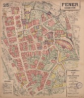 | Plan d'assurances. Fener. Corne d'Or. No: 25. | Jacques Pervititch | Nisan 1929 - April 1929 |
 | Bölümsel İstanbul haritaları - Partial Istanbul maps | - | - |