SEARCH
FILTER
REFINE
| Preview | Title | Creator | Issue Date |
|---|---|---|---|
 | Bulletin de Presse, issues 174-189. | - | 1929-01-06; 1929-04-21 |
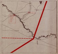 | Map of secretly allocated troops of the ‘Armée Française du Levant’ [French Army in the East]. The map shows the region between the city of Deir ez-Zor (Syria) and the Syrian-Iraqi border. | ‘Bureau Topographique de l’Armée Française du Levant’ (Topographic Office of French Army in the East) | 1924-12 |
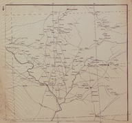 | Route Map (Carte Routière) of the Syrian and Lebanese coast region between the cities of Tripoli (Lebanon) and Latakia (Syria). | ‘Bureau Topographique de l’Armée Française du Levant’ (Topographic Office of French Army in the East) | 1924-11 |
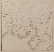 | Route Map (Carte Routière) of the region around the Gulf of Iskenderun. | ‘Bureau Topographique de l’Armée Française du Levant’ (Topographic Office of French Army in the East) | 1924-11 |
 | Bulletin de Presse, issues 17-28. | - | 1925-11-29; 1926-02-14 |