 | Route Map (Carte Routière) of the Syrian and Lebanese coast region between the cities of Tripoli (Lebanon) and Latakia (Syria). | ‘Bureau Topographique de l’Armée Française du Levant’ (Topographic Office of French Army in the East) | 1924-11 |
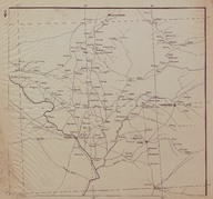
 | French Mandate of Syria and Lebanon Province Map. The map shows the region between the city of Deir ez-Zor (Syria) and the Syrian-Iraqi border. | ‘Bureau Topographique de l’Armée Française du Levant’ (Topographic Office of French Army in the East) | - |
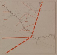
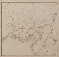 | Route Map (Carte Routière) of the region around the Gulf of Iskenderun. | ‘Bureau Topographique de l’Armée Française du Levant’ (Topographic Office of French Army in the East) | 1924-11 |
| Photo of young woman in the beach | Bahkl-Onuque. Photography, Alexanderia | - |
| Photo of a woman in a yard of Château de Valensay (Yerri), France. | - | 1928-04 |
 | A studio photo of a woman | Phébus, Constantinople | - |
 | A view of sea landscape | - | - |
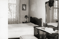
| Photos of a kitchen and a bedroom | - | - |
 | Photo of a bride and a groom | - | - |
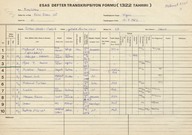
| Beşiktaş, Sinan Paşa-i Cedid Mahallesi, Yıldız Posta Caddesi'ndeki 47 numaralı hanenin 1322 h./1907 tarihli nüfus sayımına ait esas defteri transkripsiyon formları - Transcription forms from the 1322 AH (1907 AD) census, reproduced from the Defter-i Esas (Main Register): House no: 47, Yıldız Posta Street, Sinan Paşa-i Cedid Quarter in Beşiktaş. | - | 1982-07-15 |