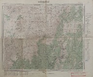
Saimbeyli, Adana (Ölçek - Scale 1:200000)
| DC Field | Value | Language |
|---|---|---|
| dc.contributor | Harita Genel Müdürlüğü - General Directorate of Mapping | |
| dc.date.accessioned | 2018-09-24T16:52:08Z | - |
| dc.date.available | 2018-09-24T16:52:08Z | - |
| dc.date.issued | 1949 | |
| dc.identifier | APLHUM036 | |
| dc.identifier.other | 108128 | |
| dc.identifier.uri | https://archives.saltresearch.org/handle/123456789/124793 | - |
| dc.description | Kayseri, Elbistan, Kozan (Sis), Niğde | |
| dc.format | 60-50 cm | |
| dc.format | Baskı-Renkli - Printing-Colored | |
| dc.language | Türkçe - Turkish | |
| dc.rights | Open Access | |
| dc.title | Saimbeyli, Adana (Ölçek - Scale 1:200000) | |
| dc.type | Harita - Map | |
| dc.note | 1947 yılında yol ve isim revizyonu yapılarak 1949 yılında basılmıştır - The map was re-printed once more in 1949 by making the revision of the roads and names in 1947. | |
| dc.location | SALT Research | |
| dc.catalogedby | Sinem Gülmez | |
| dc.date.cataloged | 2012-12-31 | |
| dc.format.numberofscans | 1 | |
| dc.format.numberofpages | 1 | |
| dcterms.accrualMethod | Satın alma - Purchase | |
| Collections | Harita Umum Müdürlüğü | |
Files
| File | Description | Size | Format | |
|---|---|---|---|---|
| APLHUM036.jpg | 8.35 MB | JPEG |