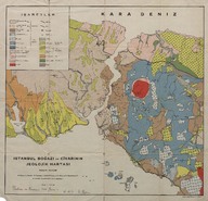
İstanbul Boğazı ve civarının jeolojik haritası (Ölçek 1:100000) - Geological map of the Bosphorus and surroundings (Scale 1:100000)
| DC Field | Value | Language |
|---|---|---|
| dc.creator | Malik Sayar | |
| dc.date.accessioned | 2018-09-24T14:18:26Z | - |
| dc.date.available | 2018-09-24T14:18:26Z | - |
| dc.identifier | APLMAS002 | |
| dc.identifier.other | 108144 | |
| dc.identifier.uri | https://archives.saltresearch.org/handle/123456789/123798 | - |
| dc.description | E. Chaput, C. Erentöz, K. Erguvanlı, I. Ketin, McCallien, A. C. Okay ve W. Pasckelmann'ın etütlerinden faydalanmak suretile yapılmıştır - This map was prepared by the help of E. Chaput, C. Erentöz, K. Erguvanlı, I. Ketin, McCallien, A. C. Okay and W. Pasckelmann's studies. | |
| dc.format | 61,5-58,3 cm | |
| dc.format | Baskı-Renkli - Printing-Colored | |
| dc.language | Türkçe - Turkish | |
| dc.rights | Open Access | |
| dc.title | İstanbul Boğazı ve civarının jeolojik haritası (Ölçek 1:100000) - Geological map of the Bosphorus and surroundings (Scale 1:100000) | |
| dc.type | Harita - Map | |
| dc.note | Haritada Dostum ve kardeşim Hadi Yener'e, 12.12.50, M.Sayar yazmaktadır - It is written To my friend and my brother, Hadi Yener, 12.12.1950, M. Sayar on the map. | |
| dc.location | SALT Research | |
| dc.catalogedby | Sinem Gülmez | |
| dc.date.cataloged | 2013-01-03 | |
| dc.format.numberofscans | 1 | |
| dc.format.numberofpages | 1 | |
| dcterms.accrualMethod | Satın alma - Purchase | |
| Collections | Malik Sayar | |
Files
| File | Description | Size | Format | |
|---|---|---|---|---|
| APLMAS002.jpg | 7.54 MB | JPEG |