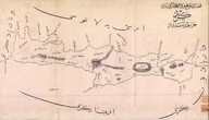
Kazaların mevki ve vasiyetlerini gösteren Girid haritasıdır.
| Dublin Core Alanı | Değer | Dil |
|---|---|---|
| dc.date.accessioned | 2018-09-24T10:11:06Z | - |
| dc.date.available | 2018-09-24T10:11:06Z | - |
| dc.identifier | APLANGRT03 | |
| dc.identifier.other | 43986 | |
| dc.identifier.uri | https://archives.saltresearch.org/handle/123456789/121070 | - |
| dc.rights | Open Access | |
| dc.title | Kazaların mevki ve vasiyetlerini gösteren Girid haritasıdır. | |
| dc.type | Plan | |
| dc.location | SALT Research | |
| dc.catalogedby | HILALS | |
| dc.date.cataloged | 14.06.2007 | |
| dc.date.acquisition | 14.06.2007 | |
| dc.format.numberofscans | 1 | |
| dcterms.accrualMethod | Purchase | |
| dc.rights.holder | Anonyme | |
| Koleksiyonlar | Girit | |
Dosyalar
| Dosya | Tanım | Boyut | Biçim | |
|---|---|---|---|---|
| APLANGRT03.jpg | 510.74 KB | JPEG |


