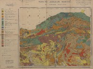
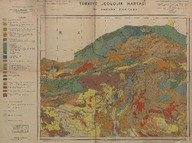
Türkiye jeolojik haritası: II. Ankara paftası (Mikyas 1:800000) - Geological map of Turkey, sheet of Ankara II (Scale 1:800000).
| DC Field | Value | Language |
|---|---|---|
| dc.contributor | Tertipleyenler - Editors: Necdet Egeran ve E. Lahn | |
| dc.coverage.spatial | Ankara | |
| dc.creator | Maden Tetkik ve Arama Enstitüsü hazırlanmış ve yayınlamıştır - Prepared and published by the Institute of Mineral Research and Exploration (Turkey). | |
| dc.date.accessioned | 2018-09-24T09:59:05Z | - |
| dc.date.available | 2018-09-24T09:59:05Z | - |
| dc.date.issued | 1942 | |
| dc.identifier | APLMTA001 | |
| dc.identifier.other | 108155 | |
| dc.identifier.uri | https://archives.saltresearch.org/handle/123456789/121026 | - |
| dc.format | 75-55 cm | |
| dc.format | Baskı-Renkli - Printing-Colored | |
| dc.language | Türkçe - Turkish | |
| dc.publisher | Kağıtçılık ve Matbaacılık, İstanbul | |
| dc.rights | Open Access | |
| dc.title | Türkiye jeolojik haritası: II. Ankara paftası (Mikyas 1:800000) - Geological map of Turkey, sheet of Ankara II (Scale 1:800000). | |
| dc.type | Harita - Map | |
| dc.note | 17-07-1942 tarihinde tamamlandı - It was completed in July 17, 1942. | |
| dc.location | SALT Research | |
| dc.catalogedby | Sinem Gülmez | |
| dc.date.cataloged | 2012-07-30 | |
| dc.format.numberofscans | 2 | |
| dc.format.numberofpages | 2 | |
| dcterms.accrualMethod | Satın alma - Purchase | |
| Collections | The Institute of Mineral Research and Exploration | |
Files
| File | Description | Size | Format | |
|---|---|---|---|---|
| APLMTA00101.jpg | 8.54 MB | JPEG | ||
| APLMTA00102.jpg | 8.4 MB | JPEG |