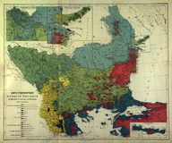
Carte éthnographique de la Turquie d'Europe et des états vassaux autonomes par G. Lejean
| DC Field | Value | Language |
|---|---|---|
| dc.date.accessioned | 2018-09-23T20:39:13Z | - |
| dc.date.available | 2018-09-23T20:39:13Z | - |
| dc.date.issued | 1861-02-11 | |
| dc.identifier | APLGL001 | |
| dc.identifier.other | 43868 | |
| dc.identifier.uri | https://archives.saltresearch.org/handle/123456789/119012 | - |
| dc.format | 55,5-46,5 cm | |
| dc.publisher | Justus Perthes. Gotha | |
| dc.rights | Open Access | |
| dc.title | Carte éthnographique de la Turquie d'Europe et des états vassaux autonomes par G. Lejean | |
| dc.type | Harita - Map | |
| dc.note | Carte accompagnant le texte de Dr. A. Petermann. Mittheilungen aus Justus Perthes Geographischer-Anstalt über wichtige neue Erforschungen auf dem Gesammtgebiete der Geographie. | |
| dc.location | SALT Research | |
| dc.catalogedby | HILALA | |
| dc.date.cataloged | 03.04.2006 | |
| dc.date.acquisition | 03.04.2006 | |
| dc.format.numberofscans | 2 | |
| dc.format.numberofpages | 1 | |
| dcterms.accrualMethod | Purchase | |
| dc.rights.holder | Guillaume Lejean | |
| Collections | Guillaume Lejean | |
Files
| File | Description | Size | Format | |
|---|---|---|---|---|
| APLGL001.jpg | dc:location: OBK | 1.94 MB | JPEG | |
| APLGL001E001.jpg | 508.32 KB | JPEG |