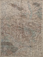
Edirne haritası - Map of Adrinopel
| DC Field | Value | Language |
|---|---|---|
| dc.date.accessioned | 2018-09-23T20:36:21Z | - |
| dc.date.available | 2018-09-23T20:36:21Z | - |
| dc.identifier | APLANEDI02 | |
| dc.identifier.other | 108049 | |
| dc.identifier.uri | https://archives.saltresearch.org/handle/123456789/118946 | - |
| dc.format | 44,5-58 cm | |
| dc.format | Baskı-Renkli - Printing-Colored | |
| dc.language | Hırvatça - Croatian | |
| dc.language | Bulgarca - Bulgarian | |
| dc.language | Almanca - German | |
| dc.publisher | Artaria and Co. Wien | |
| dc.rights | Open Access | |
| dc.subject | Edirne - Adrianople | |
| dc.title | Edirne haritası - Map of Adrinopel | |
| dc.type | Harita - Map | |
| dc.note | Geripp: Offiz. K. Maschka, Terrain Offiz G. Leitner | |
| dc.location | SALT Research | |
| dc.catalogedby | Sinem Gülmez | |
| dc.date.cataloged | 2012-06-26 | |
| dc.format.numberofscans | 1 | |
| dc.format.numberofpages | 1 | |
| dcterms.accrualMethod | Satın alma - Purchase | |
| Collections | Edirne | |
Files
| File | Description | Size | Format | |
|---|---|---|---|---|
| APLANEDI02.jpg | 8.82 MB | JPEG | ||
| APLANEDI02A1.jpg | 5.95 MB | JPEG |