| File | Description | Size | Format | |
|---|---|---|---|---|
| APLOS01001.jpg | 914.65 KB | JPEG | ||
| APLOS01002.jpg | 963.43 KB | JPEG | ||
| APLOS01003.jpg | 981.56 KB | JPEG | ||
| APLOS01004.jpg | 721.32 KB | JPEG | ||
| APLOS01005.jpg | 485.79 KB | JPEG |
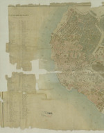
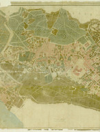
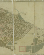
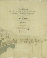
1860
RIGHTS STATEMENT
Salt is a partner of Flickr Commons. All visual materials within Flickr Commons and digitized by Salt Research which are accessible via saltresearch.org are shared under the Creative Commons license:
This material is provided solely for the purpose of individual research. It can be used under Creative Commons Attribution-NonCommercial-NoDerivatives 4.0 International (CC BY-NC-ND 4.0) license. The terms specified hereunder:
• The creator or the licensor of the work should be stated in all copies,
• Copies of documents, or documents created from copies can not be used commercially,
• Documents can not be remixed, transformed or built upon.
For each use, credits should be given as stated in the record.
(e.g. Salt Research, Harika-Kemali Söylemezoğlu Archive)
For any rights requests outside of personal research purposes, please contact Salt Research via salt.research@saltonline.org