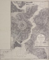
The Bosporus (Bosphorus)
| DC Field | Value | Language |
|---|---|---|
| dc.provenance | Harika, Kemali Söylemezoğlu Arşivi -Harika, Kemali Soylemezoglu Archive | |
| dc.contributor | 4 March 1905, under the Superintendence of Captain A. Mostyn Field, Hydrographer. South entrance and additional topography by Captain W. J. L. Wharton, R. N., 1880. | |
| dc.coverage.spatial | Kemali Söylemezoğlu evrakları - Kemali Soylemezoglu documents | |
| dc.creator | Surveyed by Messrs. C. H. Ploix and Manen 1854 under the direction of Admiral Hamelin of the French. | |
| dc.date.accessioned | 2018-09-23T11:58:47Z | - |
| dc.date.available | 2018-09-23T11:58:47Z | - |
| dc.date.issued | 1915-11-19 | |
| dc.identifier | APLPM001 | |
| dc.identifier.other | 83077 | |
| dc.identifier.uri | https://archives.saltresearch.org/handle/123456789/114904 | - |
| dc.format | 87,4-104 cm | |
| dc.format | Printed-Black&White | |
| dc.language | İngilizce - English | |
| dc.publisher | London, published at the Admiralty. | |
| dc.rights | Open Access | |
| dc.subject | İstanbul - Istanbul | |
| dc.title | The Bosporus (Bosphorus) | |
| dc.type | Harita - Map | |
| dc.note | Chibukli Bay to Dikili Rock by the officiers of H. M. S. Spitfire 1853. Engraved 1905. New edition 19th November 1915. | |
| dc.location | SALT Research | |
| dc.catalogedby | Sinem Gülmez | |
| dc.date.cataloged | 2012-08-27 | |
| dc.date.acquisition | 2010-06-28 | |
| dc.format.numberofscans | 1 | |
| dc.format.numberofpages | 1 | |
| dcterms.accrualMethod | Donation | |
| dc.rights.holder | Söylemezoğlu Ailesi - Söylemezoğlu Family | |
| Collections | C. H. Ploix and Manen | |
Files
| File | Description | Size | Format | |
|---|---|---|---|---|
| APLPM001.jpg | 1.52 MB | JPEG |