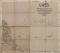
Rumeli-i Şahane haritası (1:210000 mikyası yani bir santimetre (2100) metreyi irâe eder.) - Map of Rumelia (Scale 1:210000, one centimeter shows 2100 meters.)
| DC Field | Value | Language |
|---|---|---|
| dc.date.accessioned | 2018-09-22T18:39:06Z | - |
| dc.date.available | 2018-09-22T18:39:06Z | - |
| dc.date.issued | 1912 | |
| dc.date.issued | 1913 | |
| dc.identifier | APLEH097 | |
| dc.identifier.other | 108107 | |
| dc.identifier.uri | https://archives.saltresearch.org/handle/123456789/111018 | - |
| dc.description | Ahtabolu, Midye | |
| dc.format | 74,2-66 cm | |
| dc.format | Baskı-Renkli - Printing-Colored | |
| dc.language | Osmanlı Türkçesi - Ottoman Turkish | |
| dc.publisher | Erkân-ı Harbiye-i Umûmiye | |
| dc.rights | Open Access | |
| dc.subject | İstanbul | |
| dc.title | Rumeli-i Şahane haritası (1:210000 mikyası yani bir santimetre (2100) metreyi irâe eder.) - Map of Rumelia (Scale 1:210000, one centimeter shows 2100 meters.) | |
| dc.type | Harita - Map | |
| dc.note | Sene: 1328. Saye-i füyûzât-ı sermaye-i cenâb-ı zillullahide Erkân-ı Harbiye-i ikşâf postaları taraflarından tashîh ve Erkân-ı Harbiye-i Umûmiye Dairesi Beşinci Fen Şubesi marifetiyle tersîm olunarak bu kerre daire-i mezkûre matbaasında tab ve temsîl olunmuştur - It was revised and published by Erkân-ı Harbiye and drawn by Erkân-ı Harbiye-i Umûmiye, 5th Tecnique Branch. | |
| dc.location | SALT Research | |
| dc.catalogedby | Sinem Gülmez | |
| dc.date.cataloged | 2013-01-03 | |
| dc.format.numberofscans | 2 | |
| dc.format.numberofpages | 1 | |
| dcterms.accrualMethod | Satın alma - Purchase | |
| Collections | Erkan-ı Harbiye | |
Files
| File | Description | Size | Format | |
|---|---|---|---|---|
| APLEH097.jpg | 7.52 MB | JPEG | ||
| APLEH097A1.jpg | 9.05 MB | JPEG |