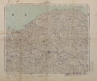
Ankara haritası (1:800000). 1932 senesi yol ve mülki idare merkezini gösterir - Map of Ankara (Scale 1:800000) It shows the road and civil administration center for the year 1932.
| DC Field | Value | Language |
|---|---|---|
| dc.contributor | Harita Umum Müdürlüğü - General Directorate of Mapping | |
| dc.date.accessioned | 2018-09-21T15:37:43Z | - |
| dc.date.available | 2018-09-21T15:37:43Z | - |
| dc.date.issued | 1933 | |
| dc.identifier | APLHUM039 | |
| dc.identifier.other | 108131 | |
| dc.identifier.uri | https://archives.saltresearch.org/handle/123456789/102291 | - |
| dc.format | 72-58,2 cm | |
| dc.format | Baskı-Renkli - Printing-Colored | |
| dc.language | Türkçe - Turkish | |
| dc.rights | Open Access | |
| dc.title | Ankara haritası (1:800000). 1932 senesi yol ve mülki idare merkezini gösterir - Map of Ankara (Scale 1:800000) It shows the road and civil administration center for the year 1932. | |
| dc.type | Harita - Map | |
| dc.note | Birinci basılış - First edition | |
| dc.location | SALT Research | |
| dc.catalogedby | Sinem Gülmez | |
| dc.date.cataloged | 2012-12-31 | |
| dc.format.numberofscans | 1 | |
| dc.format.numberofpages | 1 | |
| dcterms.accrualMethod | Satın alma - Purchase | |
| Collections | Harita Umum Müdürlüğü | |
Files
| File | Description | Size | Format | |
|---|---|---|---|---|
| APLHUM039.jpg | 10.4 MB | JPEG |