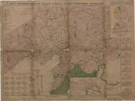
Carte Ethnographique du Vilayet d'Adana et des Territoires Avoisinants (Echelle 1: 800.000) - Adana Vilayeti ve civarının etnografik haritası (Ölçek 1: 800.000) - Ethnographic map of Vilayet Adana and neighboring territories (Scale 1: 800.000)
| DC Field | Value | Language |
|---|---|---|
| dc.date.accessioned | 2018-09-20T16:29:24Z | - |
| dc.date.available | 2018-09-20T16:29:24Z | - |
| dc.date.issued | 1920 | - |
| dc.identifier | ASTEO006 | - |
| dc.identifier.other | 126413 | - |
| dc.identifier.uri | https://archives.saltresearch.org/handle/123456789/100294 | - |
| dc.format | 69,3-51,9 cm | - |
| dc.format | Baskı - Print | - |
| dc.format | Renkli - Colored | - |
| dc.language | Fransızca - French | - |
| dc.rights | Open Access | - |
| dc.subject | Osmanlı dönemi | - |
| dc.subject | Ottoman period | - |
| dc.title | Carte Ethnographique du Vilayet d'Adana et des Territoires Avoisinants (Echelle 1: 800.000) - Adana Vilayeti ve civarının etnografik haritası (Ölçek 1: 800.000) - Ethnographic map of Vilayet Adana and neighboring territories (Scale 1: 800.000) | - |
| dc.type | Harita - Map | - |
| dc.location | SALT Research | - |
| dc.catalogedby | Masum Yıldız | - |
| dc.date.cataloged | 2018-01-26 | - |
| dc.format.numberofscans | 1 | - |
| dc.format.numberofpages | 1 | - |
| dcterms.accrualMethod | Satın alma - Purchase | - |
| dc.rights.holder | SALT Araştırma - SALT Research | - |
| Collections | Adana | |
Files
| File | Description | Size | Format | |
|---|---|---|---|---|
| ASTEO006.jpg | 5.56 MB | JPEG |